What Is the Strait of Hormuz? Why It Matters for Oil, Shipping, Flights, and Global Trade
The Strait of Hormuz is one of the most important waterways in the world. It is a narrow sea passage, but it has a very big impact on oil, shipping, trade, and global prices. When the Strait of Hormuz is in the news, many people want clear answers: What is it? Where is it? Why does it matter so much? Can it be closed? And how does it affect ordinary people?
This guide explains the Strait of Hormuz in simple language. It is written for common readers who want to understand the topic without technical jargon. It also covers the latest concerns around disruption, oil prices, shipping, and flights.
What Is the Strait of Hormuz?
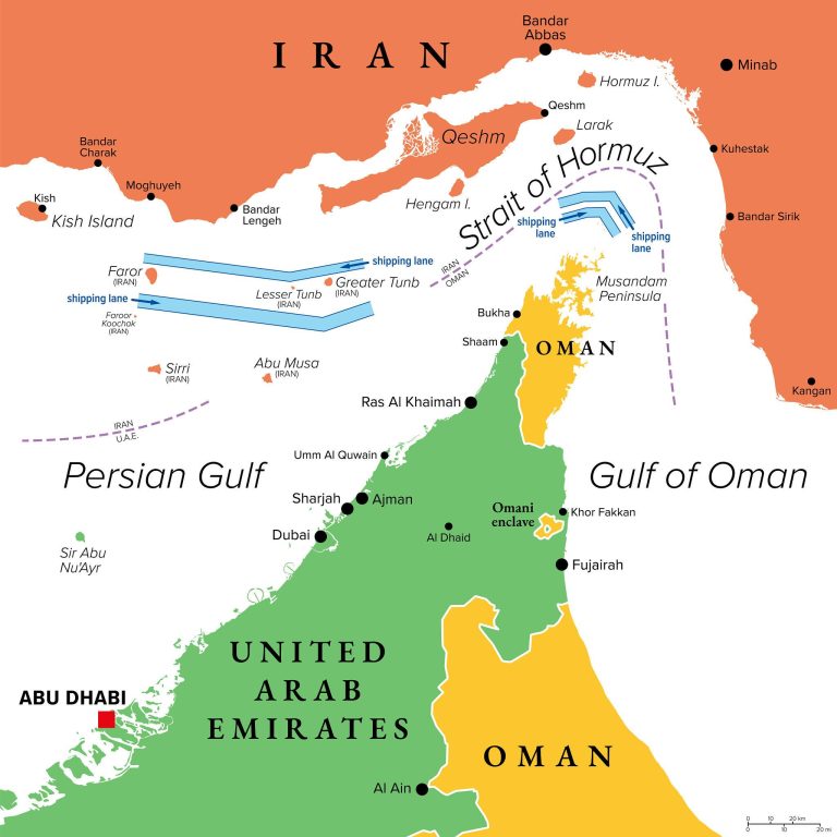
The Strait of Hormuz is a narrow waterway that connects the Persian Gulf to the Gulf of Oman and then to the Arabian Sea. In simple terms, it is the main sea exit for many Gulf countries that export oil and gas to the rest of the world.
A useful way to think about it is as a narrow gate. Huge amounts of energy and shipping pass through that gate. Because the route is narrow and so important, even partial disruption can create serious economic and political consequences.
Where Is the Strait of Hormuz Located?
The Strait of Hormuz is located between Iran to the north and Oman to the south. It links the Persian Gulf with the Gulf of Oman and the Arabian Sea. That location is what makes it strategically important: ships carrying oil, gas, and goods from the Gulf often have to pass through this route before reaching wider international waters.
A map of the Strait usually shows:
- Iran on the northern side
- Oman on the southern side
- The Persian Gulf behind it
- The Gulf of Oman and Arabian Sea beyond it
Once you look at the map, the reason for its importance becomes much easier to understand.
Why Is the Strait of Hormuz Important?
The Strait of Hormuz is important because it is one of the world’s main oil transit chokepoints. A very large share of global seaborne oil trade passes through it every day, which is why governments, markets, and businesses watch it so closely.
It matters for five simple reasons.
1. A huge amount of oil passes through it
This is the biggest reason the world watches the Strait so closely. If this route is disrupted, oil markets react quickly.
2. Gas shipments also rely on it
The Strait matters not only for crude oil but also for liquefied natural gas. That means it affects more than one energy market.
3. Shipping depends on safe passage
Oil tankers, LNG carriers, and other vessels rely on stable movement through the area. Even when ships are still moving, delays, fear, rerouting, and insurance problems can reduce normal traffic.
4. It can affect prices around the world
Problems in Hormuz can push up energy costs, freight costs, and wider market anxiety. That can eventually affect petrol prices, transport costs, and some airline costs.
5. It is tied to regional conflict
Because it sits in a sensitive region, tension there is watched very closely by governments, markets, and the media.
Who Controls the Strait of Hormuz?
This question sounds simple, but the real answer is more complicated. Iran and Oman are the countries on either side of the Strait, so geography gives both countries major importance. But “control” can mean several different things:
- who borders the route
- who can influence safety
- who can threaten transit
- who can shape the confidence of ship operators
In practice, the Strait is shaped by geography, regional power, maritime law, and military presence. That is why people often debate “control” in political and security terms rather than as a simple yes-or-no legal answer.
Can the Strait of Hormuz Be Closed?
The Strait of Hormuz can face serious disruption, restriction, or practical closure. But there is a difference between a full formal closure and a situation where transit becomes dangerous, heavily delayed, or limited to selected ships.
That means the better question is often not just “Is it closed?” but “Can ships move safely and normally?” Even partial disruption can be enough to affect oil prices, shipping behavior, and business planning.
History of Strait of Hormuz Tensions
The Strait of Hormuz has a long history as a pressure point in energy and security. It has repeatedly drawn attention during military stand-offs, tanker incidents, and periods of heightened tension involving Iran, Gulf states, and outside powers.
That history matters because it explains why markets react quickly whenever new threats emerge.
The basic pattern is familiar:
- tension rises in the region
- ship safety becomes a concern
- markets fear disruption
- oil prices react
- governments and businesses begin contingency planning
So when people see fresh Hormuz headlines, they are not reacting to an unknown place. They are reacting to a route with a long record of strategic importance.
Strait of Hormuz Map Explained
A map makes the Strait easier to understand than any long definition. The key thing a map shows is how narrow the route is and how it acts as the main outlet from the Persian Gulf into wider seas. Because many major Gulf exporters rely on this passage, the map helps explain why it is called a chokepoint.
A simple map explanation should highlight:
- the Strait between Iran and Oman
- the Persian Gulf behind it
- the Gulf of Oman ahead of it
- the route into the Arabian Sea
- why ships cannot easily avoid it at full scale
How Much Oil Passes Through the Strait of Hormuz?
A very large amount of oil passes through the Strait of Hormuz. This is why the Strait is regularly described as one of the world’s most important oil transit chokepoints.
For common readers, the most important point is not memorizing the exact figure. It is understanding the scale:
- this is not a minor regional route
- it handles a huge share of maritime oil movement
- disruption here matters globally, not just locally
Countries Most Affected by the Strait of Hormuz
The countries most affected fall into a few broad groups.
Gulf oil and gas exporters
Countries that send energy exports out through the Persian Gulf are directly exposed because they depend on the Strait to reach customers.
Countries highly dependent on Gulf energy
Importers that buy oil and gas from the Gulf can be affected through higher prices, delayed shipments, or supply risk.
Economies heavily exposed to oil revenue
Countries that rely strongly on oil exports can be hit hard if the Strait is disrupted because production, revenue, and investor confidence may all suffer.
Consumers everywhere
Even people far from the Gulf can be affected through petrol prices, airline costs, shipping costs, and inflation pressure.
Alternative Routes if the Strait of Hormuz Is Disrupted
There are some alternatives, but none fully replace the Strait at the same scale.
In simple terms, the alternatives include:
- pipelines that bypass some Strait exposure
- strategic oil reserve releases
- rescheduling and rerouting
- sourcing from other regions
But these alternatives have limits. Capacity is not unlimited, costs can rise, and response is often slower than normal maritime flows. That is why even partial disruption in Hormuz still shakes markets.
Why Is the Strait of Hormuz Trending Right Now?
The Strait of Hormuz trends whenever tension in the region becomes a direct global concern. People search for it because they want fast answers to practical questions:
- Is it closed?
- Are ships still moving?
- Will oil prices rise?
- Will flights get more expensive?
- Which countries are most exposed?
That mix of geopolitics and everyday cost impact is what drives huge search interest.
Is the Strait of Hormuz Closed Today?
The simplest way to answer this question is to understand that the Strait may not need to be fully blocked to create a major global impact.
A useful way to think about the situation is:
- fully open
- open but disrupted
- severely restricted
- effectively closed
For ordinary readers, the key point is this: if ships cannot move safely, cheaply, and normally, the economic effect can be serious even without a complete shutdown.
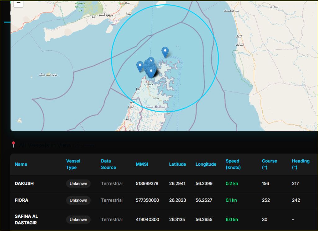
Latest Strait of Hormuz Shipping Update
The most useful shipping update is one that tells readers not just whether ships are moving, but whether shipping is normal.
A simple shipping summary should answer:
- Are ships still crossing?
- Are there delays?
- Are operators rerouting?
- Are insurance and freight costs rising?
- Are exporters and importers changing plans?
When the Strait is under pressure, shipping is often not fully normal even if some vessels continue to move.
What the Strait of Hormuz Means for Oil Prices
The Strait of Hormuz matters for oil prices because markets react to both actual disruption and the fear of future disruption.
For ordinary people, this matters because higher oil prices can eventually feed into:
- petrol prices
- delivery costs
- transport bills
- airline costs
- wider inflation
In simple terms, when Hormuz becomes unstable, the world starts worrying about energy becoming more expensive.
What the Strait of Hormuz Means for Flights and Airfares
The Strait affects flights mainly through fuel. If oil prices rise, jet fuel usually becomes more expensive too. Airlines may respond with fare increases, tighter route economics, or added pressure on travel pricing.
For travelers, the practical meaning is simple:
- fuel costs can rise
- some ticket prices may face upward pressure
- airline planning becomes harder during regional instability
Final Takeaway
The Strait of Hormuz matters because it is one of the clearest examples of how geography can shape the global economy. It is a narrow route between Iran and Oman, but it influences oil supply, shipping confidence, gas trade, freight costs, airline economics, and market sentiment worldwide.
For most readers, the simplest conclusion is this: the Strait of Hormuz is important because so much of the world depends on what happens in that narrow stretch of water.
FAQs
What is the Strait of Hormuz in simple terms?
It is a narrow waterway between Iran and Oman that acts as a major route for oil, gas, and shipping.
Why does the Strait of Hormuz matter so much?
Because a very large share of global maritime oil trade passes through it, making it a critical chokepoint.
Is the Strait of Hormuz closed right now?
The best way to understand the question is to focus on whether shipping is normal, disrupted, restricted, or effectively blocked.
Does the Strait of Hormuz affect oil prices?
Yes. Markets often react quickly to threats or disruption there because of its importance to global energy flows.
Can the Strait of Hormuz affect flights?
Yes. Higher oil prices can increase jet fuel costs, which may put pressure on airline fares.
Are there alternatives if the Strait is disrupted?
There are some pipeline and rerouting options, but they do not fully replace the Strait’s normal capacity.